Australia Weather Alert: Heatwave & Damaging Winds
A severe and widespread weather event is gripping Australia, creating a dramatic split between the eastern and southern states. While New South Wales and Queensland brace for potentially record-shattering heat, southern regions are contending with a powerful low-pressure system bringing destructive winds and rain. This dual weather crisis is interconnected, driven by a large-scale atmospheric pattern that is funneling extreme conditions across the continent.
Record-Breaking Heat Scorches the East Coast
The heatwave building over Australia's interior has now shifted eastwards, placing major population centres in its path. On Tuesday, both New South Wales and Queensland experienced their hottest October days since record-keeping began in 1910.
Notable Recorded Temperatures (Tuesday):
| Location | Region | Maximum Temperature |
|---|---|---|
| Birdsville | Outback Queensland | 46.1°C |
| Bourke | New South Wales | 44.8°C |
The Bureau of Meteorology has forecast that Wednesday could see even more records fall. The focus is now on Sydney, which is anticipating a "blistering day" with the mercury forecast to hit 39°C. If this occurs, it will easily surpass the city's existing October record of 38.2°C set two decades ago in 2004. Suburbs across the metropolitan area are expected to reach the high 30s, with some areas potentially touching 40°C.
Damaging Winds Whip Through Southern States
In stark contrast to the heat in the north, southern Australia is facing a completely different weather threat. A deep low-pressure system moving through is generating damaging winds and rain, with Victoria expected to bear the brunt of the impact.
Key Wind Forecasts for Southern Regions:
- South-West Victoria Coast: Wind gusts could reach a destructive 130 km/h.
- Melbourne & Inland Areas: Widespread winds of 90-100 km/h were expected to move through by early afternoon.
- Coastal Areas & Ranges: Even stronger gusts are possible, posing significant risks.
Due to these conditions, WorkSafe Victoria has issued urgent advisories, urging employers to reconsider outdoor work and to secure worksites to prevent materials from becoming dangerous projectiles.
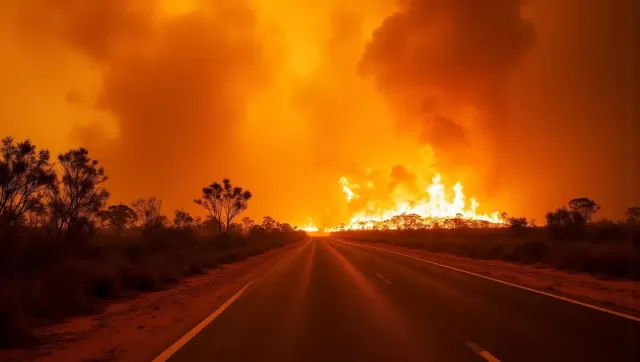
Extreme Fire Danger and Public Health Warnings
The combination of intense heat and strong winds has created a volatile environment, significantly elevating the fire risk across several regions. Total fire bans are already in place across a number of areas, including:
- Greater Sydney
- Greater Hunter
- Illawarra and Shoalhaven
- The Upper Central West Plains
Health authorities have simultaneously issued strong reminders about the dangers of heat-related illness. A spokesperson for NSW Health emphasized that hot weather can cause severe illness, worsen existing health conditions, and even be fatal.
Essential Heat Safety Tips:
- Stay Indoors: Remain inside during the hottest part of the day (typically 11 am - 5 pm).
- Keep it Cool: Close doors, windows, blinds, and curtains early in the day to trap cooler air and block out the sun.
- Hydrate Constantly: Drink plenty of water and carry a bottle with you when you are outside.
- Recognize the Signs: Be alert for symptoms of heat stress, which can include headache, dizziness, nausea, vomiting, fatigue, and muscle cramps. If you or someone else experiences these, it is crucial to cool down immediately.
The Meteorological Connection: How One System Drives Two Crises
The simultaneous occurrence of extreme heat in the east and damaging winds in the south is not a coincidence. According to Bureau of Meteorology senior meteorologist Dean Narramore, these events are closely linked.
A large pool of record-breaking heat had been building over Western Australia and the Northern Territory for several weeks. The powerful low-pressure system now moving across southern Australia is acting like a vacuum, capturing this immense heat and dragging it eastwards across the continent. This is pushing unprecedented October temperatures into NSW and Queensland, while the low-pressure system itself generates the severe winds in the south.
Long-Term Climate Context
This severe weather event is occurring against a backdrop of a warming climate. The Bureau of Meteorology notes that Australia's national annual average temperature is now approximately 1.5°C higher than it was in 1910. Scientific consensus confirms that human-induced climate change is increasing the frequency, intensity, and duration of extreme weather events, including heatwaves and severe storms.
The heat is expected to linger in south-east Queensland into the weekend, with Thursday forecast to be its hottest day. Residents across all affected states are advised to stay updated with the latest warnings from the Bureau of Meteorology and to follow all advice from local emergency services.